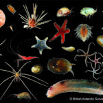
Larsen-C Benthos
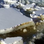
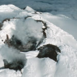
On 12 July 2017, the Larsen-C Ice Shelf calved one of the largest iceberg originating from the Antarctic Peninsula ever recorded. As iceberg A68 moves north, it leaves behind an …
Exploring the climate history and the geological structure and evolution of the rocks and mountains of Antarctica’s continental interior provides clues to past, present and future environmental change. Under-ice lakes, mountain chains buried by up to 4km ice, and sea bed sediments surrounding the frozen continent provide an unparalleled record of how the Earth’s climate has changed over millions of years.
Antarctica — our fifth largest continent — is 58-times the size of the UK. Buried beneath the snow and ice that cover more than 99% of its surface are chains of mountains the size of the Alps, while around the edge of the continent, and running across its centre, are other large mountain ranges that rise above the ice.
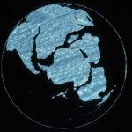
Geologists have studied the rocks in these mountains for more than a century. These rocks reveal that Antarctica has moved vast distances over millions of years. More than 500 million years ago, Antarctica straddled the equator, and the warm, shallow seas that covered the continent supported trilobites and other organisms long since extinct.
For hundreds of millions of years, Antarctica was locked in the centre of a giant continent called Gondwana. Around 150 million years ago, this supercontinent began to split apart, forming the modern continents of Australia, India, South America and Africa. At that time, instead of ice and snow, Antarctica was covered in dense forest and dinosaurs roamed its coastal plains.
Rocks and fossils tell us that the continent began to cool about 80 million years ago and around 35 million years ago, a vast ice sheet blanketed East Antarctica.
Locked in Antarctica’s rocks and in the sea bed around the continent is an unparalleled record of how the Earth’s climate has changed over millions of years. During the past 50 years, geologists at British Antarctic Survey (BAS) have built up the world’s largest archive of Antarctic rocks and fossils and made major contributions to our understanding of Antarctica’s ancient history.
Today, using BAS’s Royal Research Ship James Clark Ross to carry out surveys at sea and BAS aircraft to study remote corners of the continent, BAS geologists are using these ancient records to help predict how future climate change will affect not only Antarctica, but also the rest of the world.
Scientists at BAS are using advanced computer models to show what the Antarctic may have looked like 3 million years ago. The models suggest that during the mid-Pliocene warm period, the ice retreated significantly from the edges of the continent and was replaced by a sparse tundra vegetation. That a rise in temperature of only a few degrees centigrade had such a profound effect on Antarctica is a stark reminder of what might happen in the near future.
On 12 July 2017, the Larsen-C Ice Shelf calved one of the largest iceberg originating from the Antarctic Peninsula ever recorded. As iceberg A68 moves north, it leaves behind an …
The aim of this study is to investigate whether a technique developed to measure the basal meltrate of ice shelves can be used to monitor groundwater in arid and semi-arid …

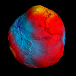
DATA AS ART is an ongoing science & art project in development at NERC’s British Antarctic Survey (BAS). It visualises science data (in its widest definition), to create stunning and …
Field Team includes: Alex Brisbourne (BAS), Andrés Rivera (CECs), Rodrigo Zamora (CECs), Field Guide (BAS). Antarctic subglacial lakes contain unique records of ice sheet history and microbial life; they may …

GOCE+Antarctica- Dynamic Antarctic Lithosphere -is an international project supported by the European Space Agency (ESA) that is using GOCE satellite gravity gradient data, GPS data and innovative 3D modelling to …

The polar regions have the capacity to amaze and astound, but despite the considerable progress of recent decades we still know far less about them than less remote parts of …
Antarctica is a unique and geographically remote environment. Field campaigns in the region encounter numerous challenges including the harsh polar climate, steep topography, and high infrastructure costs. Additionally, field campaigns …
Sea-ice is frequently cited as a likely driver and propagator of abrupt climate change because of the rapid and far-reaching impact of its feedbacks. However, numerical climate models are still …
During the Last Interglacial (129-116 thousand years ago, ka) CO2 and global temperature were both higher than they were before human industrialisation. By examining Last Interglacial climate, we thus gain …
This research focuses on investigating the glacial histories of Arctic ice sheets and ice caps using the marine geological record preserved on continental margins. By reconstructing past ice sheets, their …

26 May, 2016
A study of more than 6,000 marine fossils from the Antarctic shows that the mass extinction event that killed the dinosaurs was sudden and just as deadly to life in the polar regions.
23 January, 2016
Scientists now have a new tool to investigate the deep structure of the least understood continent on Earth
29 September, 2015
This paper revised the geological history of the Antarctic Peninsula to show how it developed over the last 500 million years, and used this history to tell us about the …

8 May, 2015
THIS year’s Lyme Regis Fossil Festival was another success, with thousands of people visiting the three-day event.
1 April, 2015
British Antarctic Survey exhibits at Lyme Regis Fossil Festival Staff from British Antarctic Survey (BAS) are displaying some amazing Antarctic fossil and biological collections at the Lyme Regis Fossil Festival …
19 November, 2014
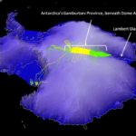
Antarctic “ghost mountains” preserved by ice sheet A new study reveals how the rugged ridgelines of East Antarctica’s ancient and mysterious ‘ghost mountains’ have been preserved for millions of years …
13 October, 2014
British Antarctic Survey hosts Chemical Air-Snow-Sea Ice Interaction workshop in Cambridge More than 60 scientists from over 15 countries are attending a workshop in Cambridge this week (13-15 October) to …
11 April, 2014
An international research team has generated the first comprehensive map of geology beneath the East Antarctic Ice Sheet that will help to understand long-term changes in the largest ice sheet …
10 March, 2014
New research suggests that life survived past ice ages with the help of volcanoes. An international collaboration, including scientists from the British Antarctic Survey, has found new evidence that the …
27 January, 2014
In this month’s International Innovation journal Dr Fausto Ferraccioli discusses how airborne geophysics can be used to uncover the geology of Antarctica and explore some of the Earth’s final frontiers. …