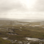
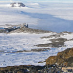
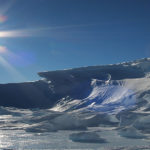
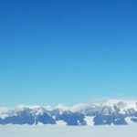
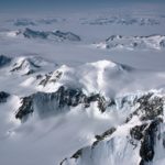
Antarctica — our fifth largest continent — is 58-times the size of the UK. Buried beneath the snow and ice that cover more than 99% of its surface are chains of mountains the size of the Alps, while around the edge of the continent, and running across its centre, are other large mountain ranges that rise above the ice.
Geologists have studied the rocks in these mountains for more than a century. These rocks reveal that Antarctica has moved vast distances over millions of years. More than 500 million years ago, Antarctica straddled the equator, and the warm, shallow seas that covered the continent supported trilobites and other organisms long since extinct.
For hundreds of millions of years, Antarctica was locked in the centre of a giant continent called Gondwana. Around 150 million years ago, this supercontinent began to split apart, forming the modern continents of Australia, India, South America and Africa. At that time, instead of ice and snow, Antarctica was covered in dense forest and dinosaurs roamed its coastal plains.
Rocks and fossils tell us that the continent began to cool about 80 million years ago and around 35 million years ago, a vast ice sheet blanketed East Antarctica.
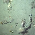
Locked in Antarctica’s rocks and in the sea bed around the continent is an unparalleled record of how the Earth’s climate has changed over millions of years. During the past 50 years, geologists at British Antarctic Survey (BAS) have built up the world’s largest archive of Antarctic rocks and fossils and made major contributions to our understanding of Antarctica’s ancient history.
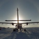
Today, using BAS’s Royal Research Ship James Clark Ross to carry out surveys at sea and BAS aircraft to study remote corners of the continent, BAS geologists are using these ancient records to help predict how future climate change will affect not only Antarctica, but also the rest of the world.
Scientists at BAS are using advanced computer models to show what the Antarctic may have looked like 3 million years ago. The models suggest that during the mid-Pliocene warm period, the ice retreated significantly from the edges of the continent and was replaced by a sparse tundra vegetation. That a rise in temperature of only a few degrees centigrade had such a profound effect on Antarctica is a stark reminder of what might happen in the near future.
In this NERC-funded project, we are generating Southern Hemisphere Westerlies (SHW) proxy records from each of the three major sectors of the Southern Ocean, focusing on subantarctic islands situated in …
The biggest uncertainty in predictions of sea-level rise is what the contribution will be from the great ice sheets on Antarctica and Greenland as climate warms. The West Antarctic Ice …
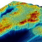
Exploring Antarctica’s ‘ghost mountains’
West Antarctic ‘rivers’ of ice
This project will reconstruct millennial-scale ice sheet change in the western Amundsen Sea Embayment, Antarctica, using high-precision exposure dating.
Understanding the contribution that polar ice sheets make to global sea-level rise is recognised internationally as urgent. The mission of this five-year project is to capture new observations and data …
The ASCCC Project has been funded by ACE (Antarctic Circumnavigation Expedition) to investigate, quantify and understand the role of polar and subpolar seabeds in the carbon cycle, particularly in response …
17 July, 2018
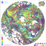
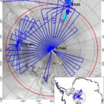
The most comprehensive magnetic map of Antarctica ever produced is published this week (15 July 2018). The new map – which includes 3.5 million line-kilometres of magnetic anomaly data collected …
15 June, 2018
Pine Island Glacier in West Antarctica is one of the fastest-flowing glaciers in Antarctica. Over the last eleven years, four major icebergs have broken off from its floating ice shelf. …
24 May, 2018
Revealing Antarctica’s hidden world
14 December, 2017
A new map of what lies beneath the Greenland Ice Sheet is published this week (Thursday 14 December 2017). By providing scientists with the most comprehensive, high resolution and accurate …
13 November, 2017
An international team of scientists, led by British Antarctic Survey (BAS), has produced a new map showing how much heat from the Earth’s interior is reaching the base of the …
5 July, 2017
Reporting this week (Wednesday 5 July) in the journal Nature, an international team of researchers led by British Antarctic Survey (BAS) explains that wind-driven incursions of warm water forced the …
20 June, 2017
Researchers have provided new evidence that large sub-glacial lakes existed under the West Antarctic Ice Sheet during the last glacial period – around 20,000 years ago – a period when …
2 March, 2017
BAS Director features in photographic portraits of women in science
23 November, 2016
New study reveals when West Antarctica’s largest glacier started retreating Reporting this week (Wednesday 23 November) in the journal Nature an international team led by British Antarctic Survey (BAS) explains …
17 November, 2016
Gondwana break-up changed the global continental configuration, leading to the opening of major oceanic gateways, shifts in the climate system and significant impacts on the biosphere, hydrosphere and cryosphere. Although …
Page 3 of 6«
1
2
3
4
5
6
»Last »