NEWS STORY: New gravity dataset
23 January, 2016
Scientists now have a new tool to investigate the deep structure of the least understood continent on Earth
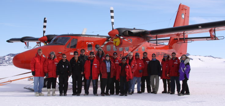
In a multinational venture to capitalize on the global scientific deployment known as International Polar Year, teams of scientists, engineers, pilots and support staff from the UK, USA, Germany, Japan, Australia and China joined forces to mount one of the most scientifically, technically and physically ambitious Antarctic projects yet undertaken: Exploration of the Gamburtsev Subglacial Mountains in the center of East Antarctica.

The Antarctica’s Gamburtsev Province (AGAP) project focuses on an invisible world in one of the most remote areas on Earth, just west of the Pole of Inaccessibility, in East Antarctica. Organised as part of a large international effort through the fourth International Polar Year, the project peered beneath the roughly 4 km-deep layer of 1.2 million-year-old glacial ice, to expose the mountains and lakes hidden below. The project involved several intersecting areas of scientific research.
Developing an understanding of the origin and the influences of the Subglacial Gamburtsev Mountains. The Gamburtsev Mountains positioned deep in East Antarctica, lie below the highest, and perhaps the coldest, place on the East Antarctic Ice Sheet — ‘Dome A’. Discovered 50 years ago, in the International Geophysical Year, the very origin of these mountains remained a complete mystery. What caused them to ever be formed?
Through the use of airborne radar and satellite measurements more than 200 subglacial lakes have been located in Antarctica. Water moves between these lakes through a complex system of under-ice rivers, streams and even swamps. Scientists believe water under the ice sheet lubricates the underside of the ice making the ice sheet slide faster. The moving water seems to have a direct link to ice sheet stability.
Much of what we know about climate change on our planet comes from ice cores. Ice cores are like climate libraries, capturing gases and atmospheric particles that provide information on the climate from earlier ice ages and warm periods. Many scientists hypothesize the oldest ice on the planet exists close to Dome A, so an ice core from this region will reveal the longest history of planetary change. Through our international collaborations, ice core samples will be recovered from this last great unknown region of Antarctica. Scientists hope that ice cores collected from Dome A will contain information that will shed new light on the origins of the Antarctic ice sheet and its role in future climate change.
This multi-national project project also included partners from seven nations, and multiple institutions.

23 January, 2016
Scientists now have a new tool to investigate the deep structure of the least understood continent on Earth
19 November, 2014
Antarctic “ghost mountains” preserved by ice sheet A new study reveals how the rugged ridgelines of East Antarctica’s ancient and mysterious ‘ghost mountains’ have been preserved for millions of years …
27 January, 2014
In this month’s International Innovation journal Dr Fausto Ferraccioli discusses how airborne geophysics can be used to uncover the geology of Antarctica and explore some of the Earth’s final frontiers. …
16 November, 2011
Gamburtsev Mountains enigma unraveled in interior East Antarctica The birth of the Gamburtsev Subglacial Mountains buried beneath the vast East Antarctic Ice Sheet — a puzzle mystifying scientists since their …
3 March, 2011
Ice structures found among hidden Antarctic mountains The discovery of numerous large ice structures within Antarctica’s Dome A region, the site of the buried ‘ghost mountains’, reveals new understanding about …
13 October, 2008
Challenge to discover Antarctica”s hidden world Later this month teams of scientists, engineers, pilots and support staff from British Antarctic Survey (BAS), USA, Germany, Australia, China and Japan will join …
List of airborne geophysics datasets available for this project includes:
Aeromagnetic data:
Gravity data:
Bed and surface elevation picks data:
Radar data:
Data Portal
Airborne Geophysics data can also be accessed through the new Airborne Geophysics Data Portal.
More information about the Portal can be found here: https://www.bas.ac.uk/project/nagdp/#about
Bell, R. E., F. Ferraccioli, T. T. Creyts, D. Braaten, H. Corr, I. Das, D. Damaske, N. Frearson, T. A. Jordan, K. Rose, M. Studinger and M. Wolovick (2011). “Widespread Persistent Thickening of the East Antarctic Ice Sheet by Freezing from the Base.” Science 331: 1592-1595, doi: 1510.1126/science.1200109
Ferraccioli, F., C. Finn, T. A. Jordan, R. E. Bell, L. M. Anderson and D. Damaske (2011). “East Antarctic rifting triggers uplift of the Gamburtsev Mountains.” Nature 479: 388-392, doi:310.1038/nature10566.
Rose, K. C., F. Ferraccioli, S. S. R. Jamieson, R. E. Bell, H. Corr, T. T. Creyts, D. Braaten, T. A. Jordan, P. Fretwell and D. Damaske (2013). “Early East Antarctic Ice Sheet Growth Recorded in the Landscape of the Gamburtsev Subglacial Mountains.” Earth Planet. Sci. Lett. 375: 1-12.
Creyts, T. T., F. Ferraccioli, R. E. Bell, M. Wolovick, H. Corr, K. C. Rose, N. Frearson, D. Damaske, T. Jordan and D. Braaten (2014). “Freezing of ridges and water networks preserves the Gamburtsev Subglacial Mountains for millions of years.” Geophys. Res. Lett. 41(22): 8114-8122.