Aero geophysical investigation of Institute and Moller Ice Streams
Aero geophysical investigation targeting basal boundary conditions for the Institute and Moller Ice Streams, West Antarctica
- Start date
- 1 April, 2010
- End date
- 31 March, 2013
Ice streams are fast flowing ‘rivers’ of ice which flow at velocities much greater than that of the ice around them. Despite being responsible for a relatively small proportion of the area of the Antarctic ice sheet, ice streams account for the vast majority of the ice sheet’s discharge into the Southern Ocean. A comprehensive understanding of the ice streams of the West Antarctic Ice Sheet (WAIS) is therefore critical for assessing the future stability of this ice mass and its potential contribution to global sea level. Over the last 20 – 30 years, a series of airborne geophysical surveys have targeted the Siple Coast and Amundsen Sea sectors of West Antarctica, with the primary aim of characterising ice stream flow behaviour and subglacial topography, geology,and basal hydrology).
These studies have shown that:
(i) the position, character and evolution of these zones of fast – flowing ice is partly determined by the underlying geology;
(ii) ice streams can be highly dynamic, unstable features that can undergo rapid and abrupt temporal and spatial variations in flow speed and direction.
In comparison to our detailed understanding of ice streams elsewhere in West Antarctica, we know surprisingly little about the ice streams of its Weddell Sea sector. Two important ice streams of this region, located between the Ellsworth and Pensacola Mountains, are the Institute and Möller ice streams, together responsible for approximately 20% of WAIS drainage by area. Bingham and Siegert (2007) hypothesised that, like the ice streams of the Siple Coast, the lower sectors of the Institute and Möller ice stream catchments are underlain by a widespread layer of unconsolidated marine sediments, deposited when the ice sheet was less extensive than it is today. Such sediments may facilitate unstable ice flow behaviour, which could lead to an increase in ice discharge and a rise in global sea levels.
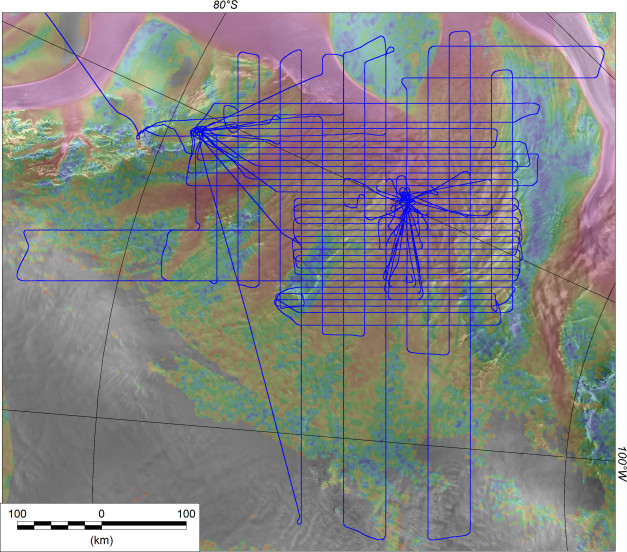
To test Bingham and Siegert’s hypothesis we have undertaken a detailed aerogeophysical survey of the Institute and Möller ice streams.

Our collaborators:
- Professor Martin Siegert Faculty of Natural Sciences, The Grantham Institute for Climate Change
- Robert Bingham
Reader in Glaciology and Geophysics / Chancellor’s Fellow, The University of Edinburgh
- David Rippin
Senior Lecturer in Physical Geography, The University of York
- Neil Ross
Lecturer in Physical Geography, Newcastle University
- Anne Le Brocq
Lecturer in Physical Geography, University of Exeter
Datasets
Data Portal
Airborne Geophysics data can also be accessed through the new Airborne Geophysics Data Portal.
More information about the Portal can be found here: https://www.bas.ac.uk/project/nagdp/#about
List of airborne geophysics datasets available for this project includes:
Aeromagnetic data:
- Ferraccioli, F., Jordan, T., Ross, N., Corr, H., Leat, P., Bingham, R., Rippin, D., Le Brocq, A., & Siegert, M. (2020). Processed line aeromagnetic data over the Institute and Moller region (2010/11 season) [Data set]. UK Polar Data Centre, Natural Environment Research Council, UK Research & Innovation. https://doi.org/10.5285/03C3180B-97EF-4923-86E1-7AC9EAB99497
Gravity data:
- Jordan, T., Ferraccioli, F., Ross, N., Corr, H., Leat, P., Bingham, R., Rippin, D., Le Brocq, A., & Siegert, M. (2020). Processed line aerogravity data over the Institute and Moller region (2010/11 season) [Data set]. UK Polar Data Centre, Natural Environment Research Council, UK Research & Innovation. https://doi.org/10.5285/BC55DF03-CAC4-4384-BFA7-57B65D969B48
Bed and surface elevation picks data:
- Ross, N., Corr, H., Bingham, R., Ferraccioli, F., Jordan, T., Le Brocq, A., Rippin, D., & Siegert, M. (2020). Processed bed elevation picks from airborne radar depth sounding across the Institute and Moller Glacier catchments in 2010/11 [Data set]. UK Polar Data Centre, Natural Environment Research Council, UK Research & Innovation. https://doi.org/10.5285/7946C497-72FC-41CB-A9B2-BF9980EFE156
Radar data:
- Ross, N., Bingham, R., Ferraccioli, F., Jordan, T., Le Brocq, A., Rippin, D., & Siegert, M. (2021). Processed airborne radio-echo sounding data from the IMAFI survey covering the Institute and Moller ice streams and the Patriot Hills, West Antarctica (2010/2011) (Version 1.0) [Data set]. NERC EDS UK Polar Data Centre. https://doi.org/10.5285/F32B298B-7906-4360-9E34-16739AF73BB7
Publications
Ross, N., R. G. Bingham, H. Corr, F. Ferraccioli, T. A. Jordan, A. M. Le Brocq, D. M. Rippin, D. A. Young, D. D. Blankenship and M. J. Siegert (2012). “Steep reverse bed slope at the grounding line of the Weddell Sea sector in West Antarctica.” Nature Geoscience 5: 393-396, doi: 310.1038/NGEO1468.
Jordan, T. A., F. Ferraccioli, N. Ross, H. F. J. Corr, P. T. Leat, R. G. Bingham, D. M. Rippin, A. le Brocq and M. J. Siegert (2013). “Inland extent of the Weddell Sea Rift imaged by new aerogeophysical data.” Tectonophysics 585(0): 137-160.
Le Brocq, A. M., N. Ross, J. A. Griggs, R. G. Bingham, H. F. Corr, F. Ferraccioli, A. Jenkins, T. A. Jordan, A. J. Payne, D. M. Rippin and M. J. Siegert (2013). “Evidence from ice shelves for channelized meltwater flow beneath the Antarctic Ice Sheet.” Nature Geoscience 6: 945–948 doi:910.1038/ngeo1977.
Rippin, D. M., R. G. Bingham, T. A. Jordan, A. P. Wright, N. Ross, H. Corr, F. Ferraccioli, A. M. Le Brocq, K. Rose and M. J. Siegert (2014). “Basal roughness of the Institute andMöller Ice Streams,West Antarctica: Process determination and landscape interpretation.” Geomorphology 214: 139-147, http://dx.doi.org/110.1016/j.geomorph.2014.1001.1021.
Rose, K. C., N. Ross, R. G. Bingham, H. F. Corr, F. Ferraccioli, T. A. Jordan, A. M. Le Brocq, D. M. Rippin and M. J. Siegert (2014). “A temperate former West Antarctic ice sheet suggested by an extensive zone of subglacial meltwater channels.” Geology 42(11): 971-974.
Ross, N., T. A. Jordan, R. G. Bingham, H. Corr, F. Ferraccioli, A. M. Le Brocq, D. M. Rippin, A. P. Wright and M. J. Siegert (2014). “The Ellsworth Subglacial Highlands: inception and retreat of the West Antarctic Ice Sheet.” Geol. Soc. Am. Bull. 126: 3-15, doi:10.1130/B30794.30791.
Siegert, M. J., N. Ross, H. Corr, B. Smith, T. A. Jordan, R. G. Bingham, F. Ferraccioli, D. M. Rippin and A. M. Le Brocq (2014). “Boundary conditions of an active West Antarctic subglacial lake: implications for storage of water beneath the ice sheet.” The Cryosphere 8: 15-24.
Wright, A., A. Le Brocq, S. Cornford, R. Bingham, H. Corr, F. Ferraccioli, T. Jordan, A. Payne, D. Rippin and N. Ross (2014). “Sensitivity of the Weddell Sea sector ice streams to sub-shelf melting and surface accumulation.” The Cryosphere 8(6): 2119-2134.
Bingham, R. G., D. M. Rippin, N. B. Karlsson, H. Corr, F. Ferraccioli, T. Jordan, A. M. Le Brocq, K. Rose, N. Ross and M. J. Siegert (2015). “Ice flow structure and ice dynamic changes in the Weddell Sea sector of West Antarctica from radar imaged internal layering.” J. Geophys. Res. 120: 655-670.
Rose, K., N. Ross, T. Jordan, R. Bingham, H. Corr, F. Ferraccioli, A. Le Brocq, D. Rippin and M. Siegert (2015). “Ancient pre-glacial erosion surfaces preserved beneath the West Antarctic Ice Sheet.” Earth Surf. Dynam. 3(1): 139-152.


