Antarctic Digital Database – December 2024 update
19 December, 2024
Continuous mapping of Antarctica reveals new topographic features
In November, we released version 7.10 of the SCAR ADD which included updated coastlines for the Alexander Island region, and new lakes, rock outcrop and moraine in the South Orkney Islands.
The SCAR ADD (Scientific Committee on Antarctic Research Antarctic Digital Database) is a seamless compilation of topographic data for Antarctica to 60°S. The ADD is managed by the Mapping and Geographic Information at the British Antarctic Survey (BAS), on behalf of SCAR, and it can be accessed here https://add.scar.org/. The mapping data is used by organisations all around the world and it contains some of the best and most recent topographic data of Antarctica.
The updated datasets in this release are all linked to published maps. When we make new maps at BAS, we must often produce new data for the region because Antarctica is changing so quickly in places. It is very likely that the coastline will have changed due to ice and glaciers either retreating or advancing, and the extent of rock outcrop and moraine will have also changed.
This release included some new data in the South Orkney Islands, largely focussed on Signy Island where BAS has one of its research stations. Signy is a fast-changing island. The ice here has retreated in recent years, exposing rock and leaving more moraine around the glaciers. More lakes and ponds have also been formed due to the melting ice and changing topography. All of these new features have been mapped and are now included in the ADD datasets.
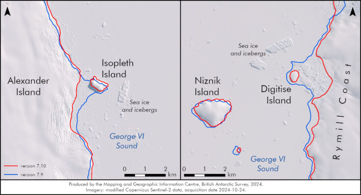
The coastline around Alexander Island on the Antarctic Peninsula has also been mapped recently. Some newly formed islands were discovered, where ice has retreated and left islands behind. The two islands shown in the images below (Isopleth Island and Digitise Island) were mapped earlier this year, and names were suggested to the UK Antarctic Place-names Committee meeting in November, where they were officially accepted.

Opening up the coastline data archive
We have also recently published versions 1 – 5 of the ADD coastlines. Version 1 of the ADD was released in 1993 and it was a vast effort between many different organisations. Mapping data was compiled from various sources with varying accuracy and currency, and assembled to form continuous datasets for the whole continent. This had never been done before and was ground-breaking for the time.
The data were originally published on CD-ROM, in tiled coverage format. Versions 2 – 5 were then published between 1998 and 2010, with improvements to the data in every version, and new data added when available. We have now worked to merge all of the tiled data into 1 file for each version, and converted the data to modern formats: GeoPackages and Shapefiles. The data is released in our data catalogue with full metadata and links to the original ADD manuals: https://data.bas.ac.uk/collections/8ff8240d-dcfa-4906-ad3b-507929842012/

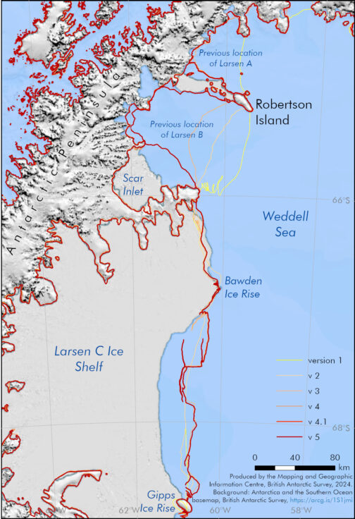
As both of the images above and below show, the data tracked changes in the coastlines and ice shelf extents of Antarctica. The Larsen Ice Shelf on the Antarctic Peninsula is an area of great change. Larsen A disintegrated in 1995 and Larsen B finally collapsed in 2002, after historic retreats in the years beforehand. The ADD coastline dataset tracked these retreats, as displayed in the map above.

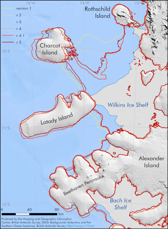
The data also tracked improvements in data accuracy. Looking at the map above, you might think that Charcot and Latady islands have moved! However, this is not the case. The data has tracked improvements in positional accuracy. The original data might have been mapped from satellite imagery with inaccurate positions, and as these positions have improved, so have the data. This map also shows real change though, with the large retreat of the Wilkins Ice Shelf.
There are further versions of the ADD coastline datasets not yet published online and we hope to do this soon. There are also all the other datasets including rock outcrop, moraine and contours which go back to version 1 as well. It is another aspiration to publish these datasets online in the future. If you have any questions about the ADD or any other geospatial queries, please email magic@bas.ac.uk.